


The Dolomites, a mountain range of breathtaking beauty in the Northern Italian Alps, are more than just a stunning backdrop for adventure. They are a geological masterpiece, a cultural crossroads, and a destination that profoundly touches the soul of those who explore their jagged peaks and serene valleys. In 2009, recognizing their exceptional universal value, UNESCO inscribed the Dolomites as a World Heritage Site.
However, this designation is unique. The Dolomites are not listed as a single, contiguous park but as a "serial property" composed of nine distinct systems. Understanding this system-based approach is the key to unlocking a deeper, more authentic experience of this incredible region. It allows for a meticulously planned journey that goes beyond the famous postcard views, revealing the diverse geology, history, and landscapes that make the Dolomites a true global treasure.
This comprehensive guide will delve into each of the nine UNESCO systems, providing the context and detail needed to plan a journey that is both inspiring and deeply informed.
Why are the Dolomites a UNESCO World Heritage site?
The Dolomites' inscription on the World Heritage List is based on two primary criteria: their exceptional natural beauty and their outstanding geological significance.
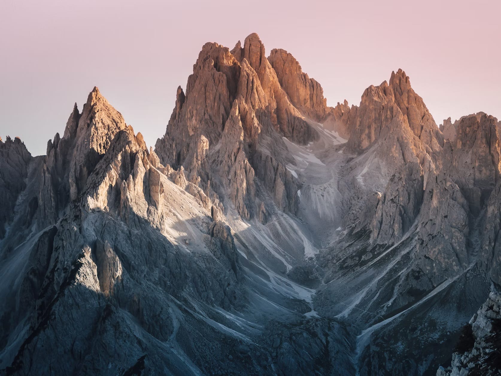
- Aesthetic value (Criterion VII): The Dolomites are widely regarded as among the most attractive mountain landscapes in the world. The dramatic verticality of their pale-colored peaks, which contrast sharply with the green valleys and meadows below, creates scenery of sublime beauty. The iconic, sheer rock walls, pinnacles, and towers are the result of unique geological and geomorphological processes. The play of light on the dolomite rock, especially during sunrise and sunset, creates a phenomenon known as Enrosadira, where the peaks glow with fiery red, pink, and orange hues—a spectacle that has inspired legends for centuries.
- Geological and geomorphological value (Criterion VIII): The mountains are a living museum of geological history. They represent one of the best-preserved examples of Mesozoic Era carbonate platform systems in the world. These peaks were once part of a shallow tropical sea, teeming with life. The fossilized coral reefs and atolls were uplifted during the Alpine orogeny, the collision of the African and European tectonic plates. The subsequent erosion by glaciers and other atmospheric agents sculpted the dramatic shapes seen today. The exposed rock layers provide an unparalleled window into the evolution of reefs and tropical marine life over 250 million years ago. The gorge of Bletterbach, in particular, offers an open book on the geological history of the last 40 million years.
The nine jewels of the Dolomites crown: a system-by-system guide
The UNESCO site comprises nine systems, covering 142,000 hectares and surrounded by a buffer zone of 85,000 hectares. Each system is a piece of a larger puzzle, representing a different chapter in the Dolomites' geological story and offering a distinct landscape and character.
1. Pelmo and Croda da Lago: a geological microcosm
- Geological Significance: This system is often considered a microcosm of the Dolomites. Monte Pelmo, known as the "Throne of God" for its majestic, isolated appearance, is a perfectly preserved example of a Triassic atoll. Its massive, solitary form rises dramatically from the surrounding valleys, showcasing the classic carbonate platform structure. The nearby Croda da Lago is geologically younger and displays the dynamic interplay of volcanic activity and reef formation.
- Exploring the System: The primary access points are the towns of San Vito di Cadore and Selva di Cadore. A classic multi-day trek is the circumnavigation of Monte Pelmo, staying at the Rifugio Venezia. For day hikers, the trail to the stunning Lago Federa, nestled beneath the jagged peaks of Croda da Lago, is a must. The area is also home to the discovery of dinosaur footprints at the base of Pelmo, adding another layer to its historical significance.
2. Marmolada: the queen of the Dolomites
- Geological Significance: Known as the "Queen of the Dolomites," the Marmolada is the highest peak in the range at 3,343 meters (10,968 feet). It is geologically distinct from its neighbors, composed primarily of limestone rather than dolomite. This difference accounts for its smoother, more massive form. It is also home to the largest remaining glacier in the Dolomites, a critical, albeit shrinking, feature of the landscape. The southern face of the Marmolada is one of the most formidable and sought-after climbing walls in the Alps.
- Exploring the System: The main access points are the villages of Malga Ciapela (with a cable car to the summit) and the Fedaia Pass. The system straddles the border between the Veneto and Trentino regions. The Museum of the Great War at Punta Serauta, accessible by cable car, offers a poignant look at the brutal high-altitude warfare that took place here between Italian and Austro-Hungarian troops during World War I. Hiking the Viel dal Pan trail offers spectacular, panoramic views of the Marmolada glacier.
3. Pale di San Martino, Pale di San Lucano, Dolomiti Bellunesi e Vette Feltrine
- Geological Significance: This is the most extensive of the nine systems. It is characterized by the vast, lunar-like Altopiano delle Pale, a high-altitude plateau of bare rock that is one of the most iconic landscapes of the Dolomites. This plateau represents an immense, fossilized atoll. The southern part of the system, the Vette Feltrine and Dolomiti Bellunesi, showcases the complex tectonic history of the region and is known for its wild, untamed nature.
- Exploring the System: Key access towns include San Martino di Castrozza, Fiera di Primiero, and Agordo. A cable car from San Martino di Castrozza transports visitors directly onto the Altopiano, offering easy access to this unique environment. The multi-day Paloronda Trek is a classic high-altitude hiking experience. The Valle di San Lucano is one of the deepest and most imposing valleys in the Alps, offering a sense of profound isolation and wildness.
4. Dolomiti Friulane e d’Oltre Piave: the wild heart
- Geological Significance: This is the wildest and most remote of the nine systems. Located in the eastern Dolomites, it is characterized by its rugged, unspoiled nature, with imposing towers and deep, narrow valleys. It represents an earlier stage of the geological processes seen elsewhere, with well-preserved Triassic reef structures. Its isolation has protected it from large-scale development, making it a haven for wilderness enthusiasts.
- Exploring the System: The main gateways are the towns of Forni di Sopra, Forni di Sotto, and the Cimolais valley. The iconic Campanile di Val Montanaia, a slender, isolated rock spire, is a symbol of this system and a legendary challenge for climbers. Hiking here requires a higher degree of self-sufficiency due to the limited number of huts and facilities, appealing to the experienced trekker seeking solitude and a genuine connection with nature.
5. Northern Dolomites (Dolomiti Settentrionali): home of the icons
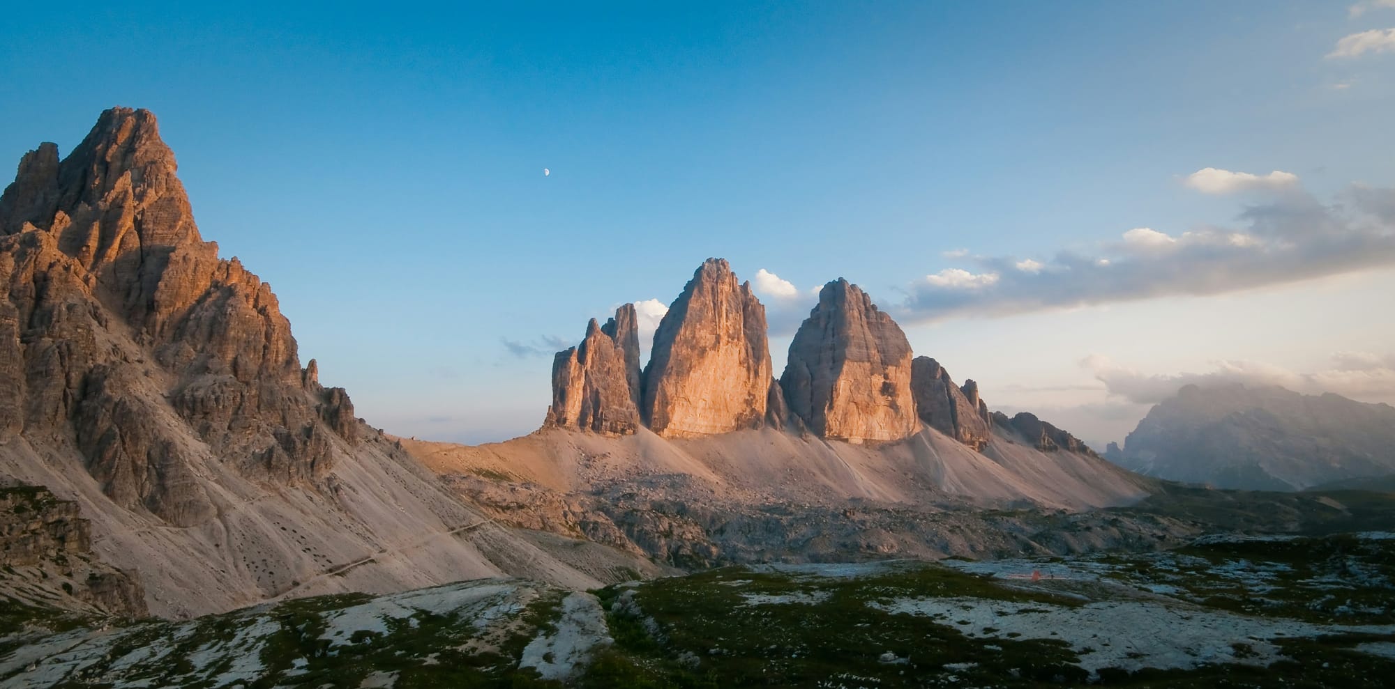
- Geological Significance: This is arguably the most famous and photographed of the nine systems. It contains a dense concentration of iconic peaks, including the Tre Cime di Lavaredo (Drei Zinnen), the Cadini di Misurina, and the Tofane. The system is a textbook example of the dramatic effects of erosion on the fossilized atolls, resulting in the classic towers, pinnacles, and sheer walls that define the popular image of the Dolomites.
- Exploring the System: The sophisticated town of Cortina d'Ampezzo is the primary hub for this region. Other key access points include the towns of Dobbiaco (Toblach) and Sesto (Sexten). The circular trail around the base of the Tre Cime di Lavaredo is one of the most popular and rewarding hikes in the Alps. The system is crisscrossed by numerous vie ferrate (iron paths) originally built during World War I, which now offer thrilling protected climbing routes. The entire area is an open-air museum of the Great War, with trenches, tunnels, and fortifications still visible.
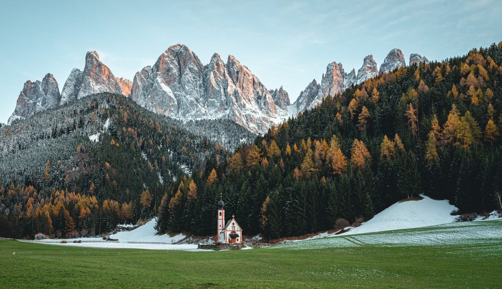
6. Puez-Odle (Puez-Geisler): the geological rosetta stone
- Geological Significance: Situated in the heart of the Dolomites, the Puez-Odle system is considered the geological "Rosetta Stone" of the region. It exposes an extraordinary range of rock formations and layers from different geological periods, all within a relatively compact area. Here, one can literally walk through millions of years of geological history, observing the transitions from volcanic rock to the various types of carbonate platforms. The sharp, needle-like spires of the Odle group are among the most recognizable peaks in the Dolomites.
- Exploring the System: The picturesque Val Gardena (with the towns of Ortisei, Santa Cristina, and Selva) and the Val di Funes are the main access points. The Adolf Munkel Trail at the foot of the Odle peaks is a relatively easy and incredibly scenic hike. For more experienced hikers, the Puez-Odle Altopiano offers a stark, rocky landscape with unparalleled geological insights.
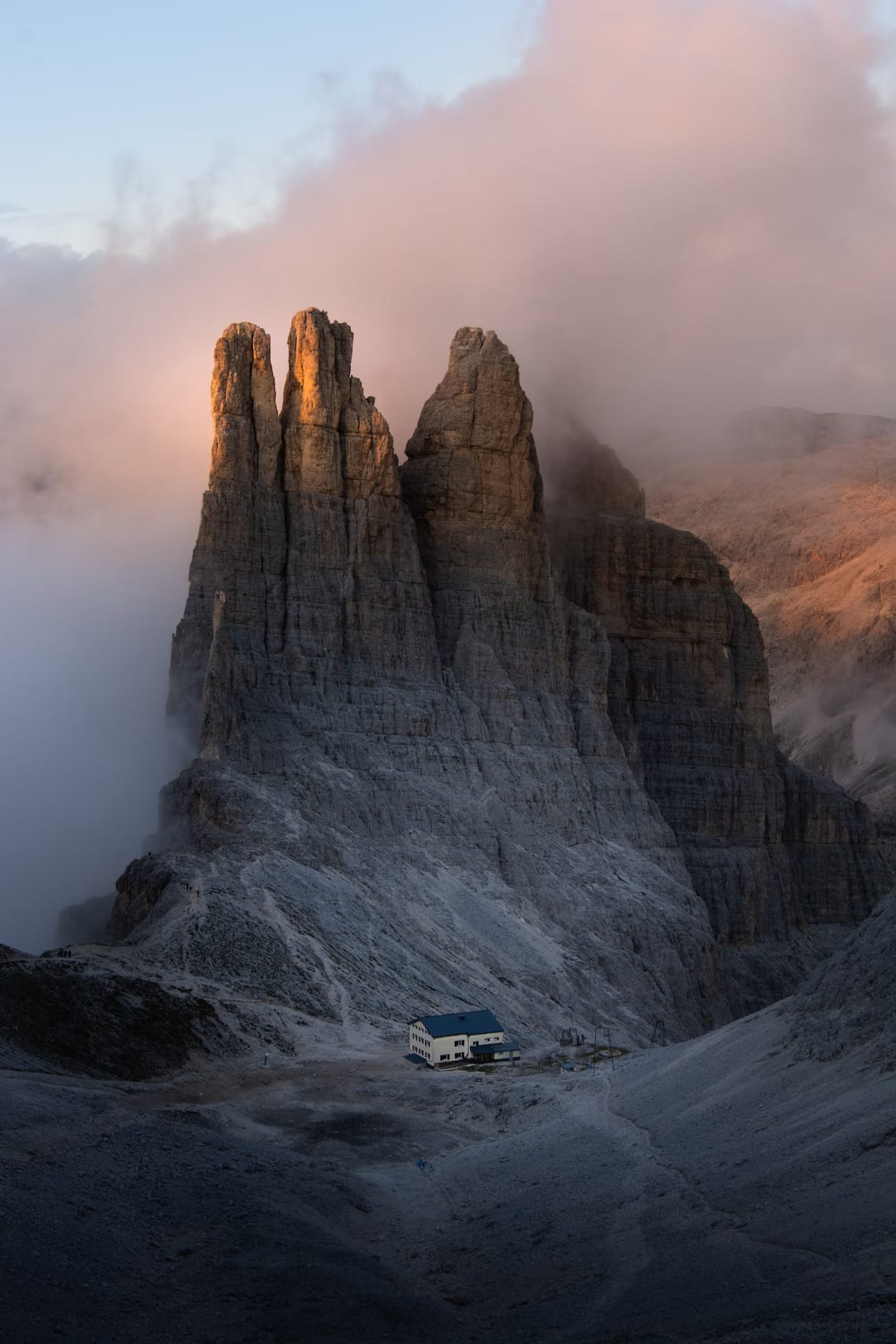
7. Sciliar-Catinaccio and Latemar (Schlern-Rosengarten)
- Geological Significance: This system showcases two distinct geological marvels. The Sciliar (Schlern) is a massive, table-top mountain that represents a perfectly preserved fossilized carbonate platform. The Catinaccio (Rosengarten), famous for the Enrosadira phenomenon that gave it its name ("Rose Garden"), is a deeply fractured reef complex. The nearby Latemar is a classic, compact atoll, offering a 360-degree view of its fossilized structures.
- Exploring the System: The Alpe di Siusi (Seiser Alm), Europe's largest high-altitude meadow, lies at the foot of the Sciliar and is a primary access point, along with the Val di Fassa and Val d'Ega. The hike across the Alpe di Siusi towards the Sciliar is a gentle introduction to the grandeur of the system. The Catinaccio is a paradise for hikers and climbers, with iconic features like the Vajolet Towers. The Latemar is famous for the Labyrinth, a chaotic field of boulders that makes for a fascinating hike.
8. Bletterbach Gorge (Rio delle Foglie): an open book of geology
- Geological Significance: While the smallest of the nine systems, Bletterbach is of immense scientific importance. It is a deep, narrow gorge carved by a small stream that has cut through 40 million years of geological history, from the volcanic rock of the early Permian to the top of the Triassic. Walking through the Bletterbach is like turning the pages of a stone book. It is renowned for its rich fossil record, including countless plant and animal fossils and dinosaur tracks, which provide a detailed picture of life before the formation of the main Dolomite reefs.
- Exploring the System: The gorge is accessible from the visitor centers in Aldino and Redagno. A well-marked trail leads down into the canyon, allowing visitors to walk along the stream bed and examine the multi-colored rock layers up close. It is a unique educational experience, profoundly different from the high-altitude landscapes of the other systems.
9. Brenta Dolomites (Dolomiti di Brenta): the western fortress
- Geological Significance: This is the only system located entirely west of the Adige River, in the Trentino region. Geologically, it is a fossilized reef of exceptional complexity, characterized by deep gorges and towering, majestic rock formations. Its isolation from the main Dolomite groups gives it a distinct character.
- Exploring the System: The chic resort town of Madonna di Campiglio is the primary access point, along with the Molveno Lake area. The Brenta Dolomites are famous for their extensive network of high-altitude trails and vie ferrate, particularly the iconic "Via delle Bocchette," a world-renowned exposed ledge route that connects numerous huts and passes. This system offers a profound sense of adventure and grandeur for the experienced mountain enthusiast.
Planning your journey through the Dolomites systems
The beauty of the UNESCO systems approach is that it encourages a more thoughtful and focused exploration of the Dolomites. Rather than rushing to see every famous peak, the visitor can choose to immerse themselves in one or two systems, gaining a deeper appreciation for their unique character.
A journey could be themed around geology, starting with the foundational story in the Bletterbach gorge, moving to the classic atoll of Pelmo, and culminating in the complex fossil record of Puez-Odle. Alternatively, an itinerary could focus on the history of the Great War in the Northern Dolomites and Marmolada, or seek the wild solitude of the Dolomiti Friulane.
By understanding the nine systems, the traveler moves from being a mere spectator to an engaged explorer, equipped with the knowledge to read the landscape, appreciate its history, and discover the true soul of this magnificent corner of Italy.
Top 10 Frequently Asked Questions about the Dolomites UNESCO Site
This final section addresses some of the deeper questions about the history, culture, and geology of this unique region.
1. What is the origin of the name "Dolomites"?
The name comes from the French geologist Déodat de Dolomieu, who in the late 18th century was the first to study and describe the specific rock type. He identified that the pale rock was a calcium magnesium carbonate, distinct from traditional limestone. The rock was named "dolomite" in his honor, and the name was eventually applied to the entire mountain range.
2. What exactly is the Enrosadira phenomenon?
Enrosadira is a Ladin term meaning "to become pink." It describes the magnificent visual effect when the pale dolomite peaks are illuminated by the light of sunrise or sunset. The unique chemical composition of the dolomite rock causes it to reflect the long, reddish wavelengths of the light, making the mountains glow in spectacular shades of pink, orange, and fiery red. This natural event is the source of many ancient myths and legends.
3. Who are the Ladin people?
The Ladins are the native inhabitants of the Dolomites, an ethnic group with a unique language and culture that predates the arrival of the Romans. Their language, also called Ladin, is a Rhaeto-Romance language that has survived for centuries in the isolated valleys of the region. Today, the Ladin culture is carefully preserved and celebrated, particularly in the valleys of Val Gardena, Val di Fassa, Val Badia, and Livinallongo.
4. How did World War I impact the Dolomites?
The Dolomites were the site of intense and brutal fighting between Italian and Austro-Hungarian forces from 1915 to 1917. This high-altitude conflict, known as the "White War," forced soldiers to battle not only each other but also the extreme cold, avalanches, and treacherous terrain. They carved extensive networks of tunnels, trenches, and fortifications directly into the mountains, the remnants of which are now preserved as open-air museums, particularly in the Marmolada and Northern Dolomites systems.
5. Why is the distinction between "dolomite" (the rock) and "limestone" important?
The distinction is fundamental to the Dolomites' appearance. While both are carbonate rocks, limestone (calcium carbonate) is more susceptible to water erosion, often resulting in softer, more rounded forms. Dolomite (calcium magnesium carbonate) is harder and more brittle. This resistance allows it to fracture into the dramatic, vertical towers, sheer cliffs, and jagged pinnacles that make the Dolomites' skyline so iconic and visually stunning. The Marmolada, primarily limestone, stands as a clear contrast with its more massive, glacier-covered shape.
6. What makes the fossil record in the Dolomites so special
The Dolomites preserve an entire fossilized marine ecosystem. Unlike sites with individual fossils, these mountains are the remnants of complete tropical atolls and reefs from the Triassic period. Scientists can study the entire structure of these ancient reefs, from the lagoons and tidal flats to the sheer outer walls. This provides an unparalleled look at the evolution of marine life and reef-building processes in a critical period of Earth's history following a mass extinction event.
7. Why is the UNESCO site "serial," with nine separate systems?
The "serial" designation was a deliberate choice to protect the most geologically significant and visually spectacular areas while excluding regions that have been more heavily developed or are less representative of the site's "Outstanding Universal Value." This approach ensures that each of the nine systems is an exceptional and well-preserved example of a specific geological feature, together telling the complete story of the Dolomites' formation without being compromised by less pristine areas in between.
8. Are the mountains still changing today?
Yes, the Dolomites are a dynamic landscape. While the tectonic uplift has slowed, the forces of erosion are constantly at work. Water, ice, wind, and gravity continue to sculpt the peaks. The freeze-thaw cycle breaks rocks apart, glaciers (like the one on Marmolada) carve out valleys, and landslides reshape the mountainsides. These ongoing geomorphological processes are part of the value recognized by UNESCO.
9. What is the cultural significance of the Altopiano (high plateau)?
The high plateaus, like the Altopiano delle Pale or the Puez-Odle Altopiano, hold a special place in the region's culture. Historically, they were used for high-altitude summer grazing (alpeggio), a practice that shaped the local economy and traditions. Today, they represent a world between the inhabited valleys and the inaccessible peaks—a place of profound silence, vast open spaces, and stark, lunar-like beauty that offers a powerful spiritual and contemplative experience.
10. How do local legends explain the mountains' appearance?
Dolomitic culture is rich with legends that personify the landscape. The most famous story explains the "Pale Mountains" by telling of a prince who married a moon princess. To make the landscape less dark and jarring for his bride, he enlisted the help of mythical creatures who spun the moonlight into threads and wove a silvery blanket over the peaks, giving them their characteristic pale color. The Enrosadira is often linked to the mythical Rose Garden of King Laurin, a dwarf king whose kingdom was turned to stone.


